This study confirms that in each of the 100 counties, the main network of single carriageways accounts for most of the road deaths outside urban areas.
Between 2012 and 2017, two studies examined serious accidents on this two-way network, depending on whether the roads belong to the main network or to the local network :
- the study to assess the possibility to decrease the speed limit to 70 km/h on the most local network (Cerema);
- the questionnaire to the county councils on the hierarchy, traffic, and accidentality of their network (Cerema-ONISR).
These analyses enabled the National Road Safety Council (CNSR) Experts Committee in 2013 to recommend that the maximum authorised speed be reduced from 90 km/h to 80 km/h on all single carriageway roads, the main network included. The measure was adopted by the government at the Inter-Ministerial Committee on Road Safety (CISR) on 9 January 2018, and implemented on 1 July 2018.
The study presented here aimed to verify that in all French counties, the network with the most traffic or with a high strategic dimension is the one with the highest number of serious accidents and the highest road mortality rate.
The road network outside urban areas is composed on one hand of motorways and dual carriageways which offer a high level of service in terms of safety, with a central separation between both directions of traffic and grade separated junctions, and on the other hand of so-called "single carriageway" or "two-way" roads.
Among single carriageway roads, some have benefited for many years from improvements to improve traffic flow or safety, such as improved bends, visibility clearances, specific lanes for turning left at intersections, stabilized shoulders, or even wide platforms including overtaking slots. These roads carry not only local but also transit traffic, rather than the secondary, narrow, slow-moving, network, which at equivalent speeds stand more dangerous.
Since 2012, several Cerema studies have examined the differences in accidentality between the two-way main network and the more local network. They enabled the CNSR's experts committee in 2013, and then the government at the CISR on 9 January 2018, to assess the differences in the impact of a measure to reduce the speed limit from 90km/h to 80km/h on two-way roads without a central separator, depending on whether the network concerned is main or more local. This choice is far from neutral in terms of the results to be expected in terms of accident reduction.
In response to requests to have this evaluation available for each French county, a survey was conducted in early 2018 with the support of local road safety observatories, coordinated by ONISR.
The survey and analysis process
The investigation focused on the accidentality on single carriageways outside urban areas between 2012 and 2016.
Among these roads, two types of networks have been identified, one of which can be described as "main", consisting of trunk roads (national roads or RN) and part of county council roads (RD), and the other as "secondary", consisting of the rest of RD. Municipal roads have very few accidents compared to their length of network as traffic is low.
The distribution of RDs in the "main" or "secondary" network was defined on the basis of the classifications used by road managers: county councils. Each county council uses between 2 and 5 categories for the management prioritisation on its road network. The prefects have contacted each county council president to collect the road network hierarchy voted by the county council.
The local road safety observatories then counted serious accidents on their county two-way roads outside urban areas between 2012 and 2016, with a breakdown for the two hierarchically highest RD categories (i.e., considered by the road manager as having either the highest traffic or the highest strategic dimension). These data were centralized by ONISR for each of the French counties (in France mainland and overseas), which presented in a report the respective weights of the main network roadways and their accidentality (road mortality).
Two "main" network perimeters were considered :
- the main network consisting only of all RNs and RDs of category 1 (hierarchically highest);
- the main network consisting of all RNs and RDs of category 1 and also RDs of category 2.
For each perimeter and each county, the ONISR have calculated:
- the length of the main road network thus defined, then its ratio to the total length of RN and RD of the county;
- the mortality 2012-2016 on bi-directional roads outside the urban area associated with this main network, then its ratio to the total mortality on bi-directional NR and RD outside the urban area of the department.
Exemple on a given county :
- for the first perimeter, the main network represents 12% of the linear of RN and RD, and accounts for 47% of deaths over the 2012-2016 period;
- for the 2nd perimeter, the main network accounts for 22% of the RN and RD linear, and accounts for 60% of deaths over the 2012-2016 period.
The value pairs thus obtained are represented, for all counties, on the chart below. The dispersion of the points around the average curve reflects in particular geographical diversity (rural or more urban counties, mountain counties, etc.).
Results
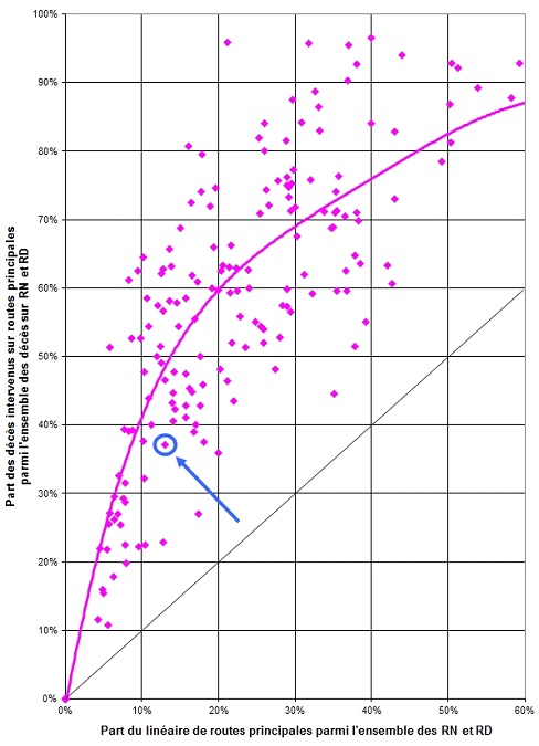 |
The value pairs thus obtained: share of mortality on main roads as a function of the linear share of the main network in relation to all trunk roads and county council roads, are shown in the graph opposite. In the county marked by the arrow, the main network represents 13% of single carriageways rn and RD network length and records 37% of the deaths recorded on single carriageways RN and RD outside urban areas. The diagonal corresponds to situations where the shares associated with network length and mortality would be identical. The main network would have been a lesser contributor to mortality if it had been positioned below the diagonal. |
The main (or most comfortable) network has a higher proportion of fatalities than its network share (in kilometres)
Thus, on average, on trunk roads and roads managed by county councils that are two-way roads without a central separator, and outside urban areas:
- 10 % of these roads, considered by the manager to have either the highest traffic or the highest strategic dimension, concentrate 38 % of all fatalities of rural single carriageways ;
- With an additional 10 % (intensity of the traffic or strategy criterion slightly lower), they represent 55 % of all fatalities. The rest of the network targeted for reduction, i.e. 80% of county councils roads and all municipal roads outside urban areas, account for only 45% of mortality.
Although it is counter-intuitive that the most comfortable network bears the highest number of fatal accidents, successive studies confirm that the benefits of lowering the speed limit lies largely with including this network.